Mnemosyne Scrolls on the Earth
Equinox Sun roads between Fusano Kuni and Izumo
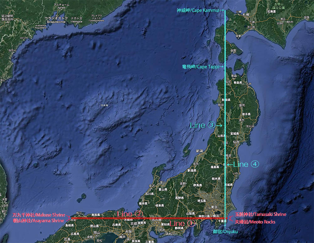
�@the outward 35��19��10��N line, the longest terrestrial lattitude line in Japan
�Athe homeward 35�� 22�� 30�� N line
Quick Journey on Two Latitude Lines
Polaris Roads between Fusano Kuni and Ezo,�Bthe 140�� 21�� 38�� E line, the longest terrestrial longitude line in Japan / �C140°21'29"E line
Introduction
Here, I introduce four straight lines on the ground of Japan. These lines are alignments consisting of ancient and historical spots and natural points. The first opportunity that I noticed these alignments was to realize several Hakusan Shrine branches in Kanazawa prefecture and Chiba prefecture are located on the same latitude line. Secondly, I expanded its width around 1.2 km and extended the line horizontally and collected interesting points on the line. I found that on these lines there were a lot of other old shrines, temples, ceremonial ruins in the ancient time, natural sacred points, which have been worshiped since ancient time such as sacred mountains and capes and modern buildings such as electric towers as well.The sun worship and the Polaris worship
The notice of the first latitude line (Line 1) led me to a next discovery of the latitude Line 2 and consequently, these two latitude lines brought me to two longitude lines (Line 3 and 4). These lines aren�ft actual roads but imaginal. However, two latitude lines would suggest the close relation to the sun worship in ancient time because these lines represent horizontal sun movements on the vernal and autumnal equinox days . Meanwhile, two longitude vertical lines indicating the North Pole would suggest the world after dark and the Polaris worship.The first idea of alignments consisting of ruins and historical points was suggested as �eLey Line�f by Alfred Watkins who was a British self-taught amateur archaeologist in 1921. Since then many alignments have been discovered all over the world mainly by people outside of academic field. In Japan, TV documentary, �eJourney on the mysterious latitude line, 34��32�fN�ionly in Japanese�j was broadcast on February 11th 1980 and it brought great response and this alignment consisting of quite important historical points, eg. Hashihaka Tumulus, Hibara-jinja Shrine,Hase-tera Temple, Ise Shrine in ancient time has become well known as �e the sun road�f . I was one of them who were fascinated by this idea. The book with the same title was published by NHK publisher and went through many editions as well. Recently, another latitude alignment called as �eGolaikou-no-michi,�ionly in Japanese�j the rising sun road�f has become popular as well. On the line, we see an incredible lin-up consisting of the most sacred and important historical and natural points in this country, such as Izumo Taish shrine, Mt. Ddaisen, Moto-Ise shrine, Tikubu island in Biwa lake, Mt Fuji, Samukawa Shrine and Yamasaki Shrine are located. But unfortunately the road has around 7 km width in a north-south direction. Considering the whole length of the line, 700 km. 7 km width, difference would be quite small but it is natural to think that this alignment consisting of selected points is the result of just accidental or biased.
It wasn�ft intended but, two latitude lines I am suggesting here were consequently separated from this �eGolaikou-no-michi and formed into the outward road and homeward road. I think that these two lines would be successful in enforcing meanings of �eGolaikou-no-michi�f and reducing 7 km difference, the width of Golaikou-no-michi to within 1 km.
It is obvious that many of ruins and points shown here rooted in ancient times but there are not enough document records. Besides that, the idea of these alignments are often in conflict with a standard knowledge in the present. For instance, we encounter incredible preciseness in location surveying, beyond common knowledge and revealed facts here conflicting with the modern theory. Furthermore, it is quite often that sealed or taboo in history emerge behind the drape of history. in other words, it is difficult that these alignments become academic objects because of theses conflicts. As an amateur, my approach couldn�ft be archaeological, folkloric and anthropological. In fact what I did was only to make these lines wider a little and extend it horizontally and then collect and list up spots, which just seem important for myself. I cannot do fact-check on all spots listed here. However, I firmly believe that these alignments are not the results of my personal delusion. They have existed in advance before I was born.
In the process of extending lines, I actually encountered Kojin-dani ruin 400 BCE discovered in 1984 �e(Line 2-29) and Isedo-tai ruin 2000 BCE�@discovered in 1992 (Line 3-31). Both ruins have become considered as epock-making discoveries in Japanese archeology. In other word, these lines are common grounds where anyone can freely enter and leave. I presume that there would be many other important points which we don�ft realize yet and are not excavated. With regard to modern buildings such as electric towers, if they are components of these alignments, it is difficult for me to say whether some people are sill conscious of these lines�f existences and whether a consistent grand plan has been inherited and sustained since the beginning. I think these lines have been huge scrolls drawn on the ground, directly and would be going to change in future. I would like to add new discoveries and new interpretation and to reedit them continuously. I long for corporation from others.
Mnemosyne Scrolls on the earth
On these lines, each point sometimes appears with contradicting and multilayered meanings at the same time and sometimes changes the contents of symbolizing depending on combination and position. There is ceaseless motions and changes. I cannot help but think of resemblance to Mnemosyne Atlas suggested by Aby Moritz Warburg. I hope these lines will be recognized as Mnemosyne Scrolls on the earth.San Francisco Peaks, the sacred mountain of the Hopi and the Zuni
Equinox Sun roads and San francisco Peaks�@
Points in common between Pueblos and Japanese
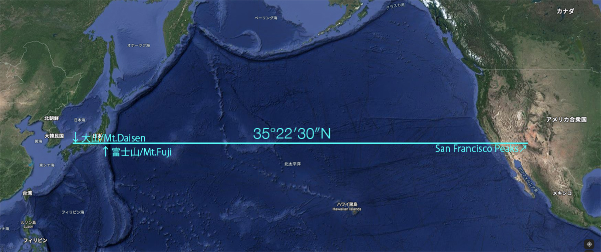
I have been interested in Art of Animism and Shamanism for a long time and Hopi Katsina dolls been fascinating me. There are a lot of variation in Hopi Katina dolls which are embodied the Katina Spirits who are believed to live on San Francisco peaks 50km far from Hopi reservation. When I was intrigued by Hopi story, I happened to want to know the latitude of San Francisco peaks and realized the fact that 6 km width between Line1 and Line 2 is almost the same range as San Francisco peaks stretching in the north-south direction. It is not easy to decide of the width of San Francisco peaks with several summits but Humphreys Peak, the highest one is located in the center of the width between Line1 and Line 2. It is difficult to insist that this is an amazing synchronicity but I cannot help thinking of an invisible but close connection between Native Americans and we, Asian. It has been recognized as a fact that Pueblo�fs ancestors including the Hopi and the Zuni immigrated from Asia via Bering Strait during Ice age.I have heard that many of their babies are born with Mongolian spots as the same as Japanese Babies. Aby Moritz Warburg researched Pueblos and wrote about their serpent worship and their skill of making pottery in his book, A Lecture on Serpent Ritual. Hopi culture seemed to have anything in common with Jomon and Yayoi culture.
The Zuni Enigma
The Zuni Enigma: A Native American People's Possible Japanese Connection�f by Nancy Yaw Davis, American Anthropologist was published in 2000,where the connection between Zuni and Japan. For her the genetic relationship between Pueblos and Asian is an accomplished fact but she tried to take a step further to research and discuss closer blood, linguistic and cultural kinship between Japanese and the Zuni than other Pueblos and to prove the possibility of Japanese immigrants in the end of Kamakura period, 13th - 14th century.In the book there are several misunderstandings between words of Japanese origin and words imported from china that one of translators admitted but this book was actually the result of deliberate researches and logical considerations. Teigo Yoshida(only in Japanse), one of the translators, a well known anthropologist himself wrote in the postscript that Yoshihiko Amino who was the leading anthropologist and famous for researching sea trade and transportation in medieval Japan, told Yoshida that he had got interested and inspired by this book. In fact, there are several records of drifters from Japan before the 19th century in United State. The most famous example was Otokichi known as John Matthew Ottoson (1818 �| January 1867). So it is�ft appropriate to criticize this book as a nonsensical book without verification.Reading the book, I was thinking of �efudaraku-tokai�f(Only in Japanese), which was a form of the ascetic practice of sacrifice performed on a drifted boat in the sea prevailing in medieval Japan.I have actually had a stereotype idea that it was a kind of �esokushin-jobutu�f(Only in Japanese) in the sea, a suicidal performance of self sacrifice. But it was said that there were a variety in �efudaraku-tokai�f, the ascetic practice of sacrifice, which wasn�ft the only style of �efudaraku-tokai�f . I have heard that there was an example that practitioners were drifted to reach Mount Potalaka. the mythical dwelling of the Buddhist bodhisattva somewhere across the sea on the boats with 30 days food. But I think I need further research for �efudaraku-tokai�f.
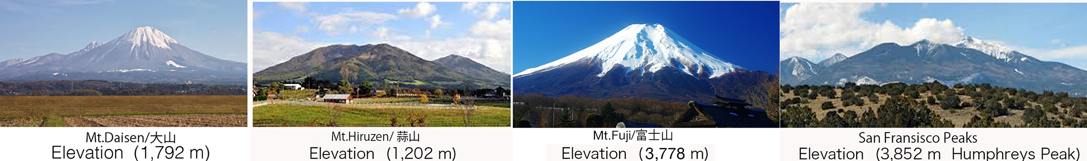
You will see bellow the images of Daisen, Hiruzen, Mt,Fuji and San Francisco Peaks in a row. The fact these great mountains located on the same latitude is coincidental but marvelous. I got a vision where the Hopi and the Zuni people get images of these mountains in their ancestors�f home land across the Pacific Ocean beyond 10000 km when they see San Francisco Peaks from their reservations.